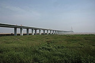
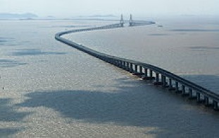
Weinan Weihe Grand Bridge
The Weinan Weihe Grand Bridge (渭南渭河特大桥) is a part of the Zhengzhou–Xi'an High-Speed Railway which connects Zhengzhou and Xi'an, in China. The bridge is 79,732 metres (261,590 ft) long crossing the Wei River twice, as well as many other rivers, highways and railways
http://en.wikipedia.org/wiki/Zhengxi_Passenger_Railway
http://en.wikipedia.org/wiki/Zhengxi_Passenger_Railway
Bang Na Expressway

The Bang Na Expressway (full name: Bang Na - Bang Pli - Bang Pakong Expressway), officially Burapha Withi Expressway (Thai: ทางพิเศษบูรพาวิถี), is a 54 km long six-lane elevated highway in Bangkok, Thailand. It is a toll road and runs above National Highway route 34,(Bang Na–Bang Pakong Road).
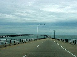
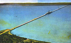
Lake Pontchartrain Causeway
The Lake Pontchartrain Causeway, or the Causeway, consists of two parallel bridges crossing Lake Pontchartrain in southern Louisiana. The longer of the two bridges is either the longest or third-longest in the world depending on definitions, measuring at 23.87 miles (38.42 km) long. The Bang Na Expressway, a viaduct in Bangkok, is longer at 54 kilometres (33.55 mi), but is excluded from most lists of longest bridges because it crosses water for only a minimal portion of its length. The newly opened Weihe Grand Bridge is longer but also classed as a viaduct.
longest bridge over water
longest bridge over water
Hangzhou Bay Bridge
Hangzhou Bay Bridge (simplified Chinese: 杭州湾大桥; traditional Chinese: 杭州灣大橋; pinyin: Hángzhōu Wān Dàqiáo), is a long highway bridge with a cable-stayed portion across Hangzhou Bay in the eastern coastal region of China. It connects the municipalities of Jiaxing and Ningbo in Zhejiang province. At 35.673 km (22 mi) in length, Hangzhou Bay Bridge is the longest trans-oceanic bridge in the world, but it does not have the longest cable-stayed main span. It is also second in the world in overall length, with the Lake Pontchartrain Causeway in the United States being 2.8 kilometers longer. Construction of the bridge was completed on June 14, 2007,[1] and an opening ceremony was held on June 26, 2007 to great domestic media fanfare. But the bridge was not opened to public use until May 1, 2008 after a considerable period of testing and evaluation.[2] The bridge shortened the highway travel distance between Ningbo and Shanghai by 120 km (75 mi) from 400 km (249 mi) and reduced travel time from 4 to 2.5 hours.[3].
Contents [hide]
longest bridge over sea
Contents [hide]
longest bridge over sea
Runyang Bridge
The Runyang Bridge (simplified Chinese: 润扬长江大桥; traditional Chinese: 潤揚長江大橋; pinyin: Rùnyáng Chángjiāng Dàqiáo) is a large bridge complex that crosses the Yangtze River in Jiangsu Province, China, downstream of Nanjing. The complex consists of two major bridges that link Zhenjiang on the south bank of the river and Yangzhou on the north. The bridge is part of the Beijing-Shanghai Expressway.
Donghai Bridge
Donghai Bridge (simplified Chinese: 东海大桥; traditional Chinese: 東海大橋; pinyin: Dōnghǎi Dàqiáo; literally "East Sea Grand Bridge") was the longest cross-sea bridge in the world until Hangzhou Bay Bridge opened on 1 May 2008. It was completed on December 10, 2005. It has a total length of 32.5 kilometres (20.2 miles) and connects mainland Shanghai and the offshore Yangshan deep-water port in China. Most of the bridge is a low-level viaduct. There are also cable-stayed sections to allow for the passage of large ships, largest with span of 420 m.
Shanghai Maglev Train
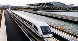
The Shanghai Maglev Train or Shanghai Transrapid (simplified Chinese: 上海磁浮示范运营线; traditional Chinese: 上海磁浮示范運營線; pinyin: Shànghǎi Cífú Shìfàn Yùnyíng Xiàn; literally "Shanghai Magnetic Levitation Demonstration Operation Line") is a magnetic levitation train (maglev) line near Shanghai, China. It is notable for being the first commercial high-speed maglev line in the world—during a test run on November 12, 2003, a Maglev vehicle achieved a Chinese record speed of 501 km/h (311 mph). The journey was designed to connect Shanghai Pudong International Airport quickly to the outskirts of central Shanghai where passengers could interchange or their final desinations in the city centre. Construction of the line began in March 2001 and public service commenced on January 1, 2004.
Atchafalaya Basin Bridge
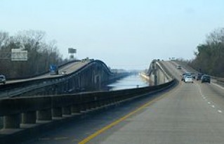
The Atchafalaya Basin Bridge is actually two parallel bridges in the US state of Louisiana between Baton Rouge and Lafayette , LA which carries Interstate 10 over the Atchafalaya Basin. With a total length of 96,095 feet (29,290 m) or 18.2 miles, it is the tenth longest bridge in the world by total length.
King Fahd Causeway
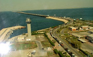
The King Fahd Causeway (Arabic: جسر الملك فهد, Jisr al-Malik Fahd) is a causeway connecting Saudi Arabia and Bahrain. Construction started during 1968 and continued until 1986, when it was officially opened to the public. The project cost a total of US$1.2 billion (SAR3 billion). One of the major contractors of the project is Ballast Nedam Group, based in the Netherlands. The four-lane road is 28 km (17 mi) long and approximately 23 m (75 ft) wide, and was built using 350,000 m2 (3,800,000 sq ft) of concrete along with 47,000 metric tonnes of reinforced steel. The causeway is constructed in three segments starting from Saudi Arabia:
Jintang Bridge
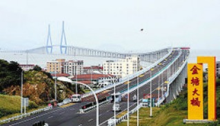
Jintang Bridge (Chinese: 金塘大桥; pinyin: Jīntáng dàqiáo) is a highway bridge with a cable-stayed bridge portion, built in Zhejiang, China on the Zhoushan Archipelago, the largest offshore island group in China. It is the longest bridge in Zhoushan Trans-oceanic Bridges with a length of 26,540 meters, connecting Jintang Island and Zhenhai, Ningbo. The main span of the bridge is a cable-stayed bridge with opposite towers. The bridge is the third longest bridge in China after Hangzhou Bay Bridge and Donghai Bridge.
Chesapeake Bay Bridge-Tunnel
he Chesapeake Bay Bridge-Tunnel (CBBT) is a 23-mile (37-km) long fixed link crossing the mouth of the Chesapeake Bay and connecting the Delmarva Peninsula's Eastern Shore of Virginia with Virginia Beach and the metropolitan area of Hampton Roads, Virginia. It replaced vehicle ferry services which operated from South Hampton Roads and from the Virginia Peninsula from the 1930s until completion of the bridge-tunnel in 1964. Much of the ferry equipment used by the Little Creek-Cape Charles Ferry service was then sold and redeployed to start a new ferry service across the 17-mile mouth of the Delaware Bay between Cape May, New Jersey and Lewes, Delaware. [2]
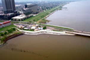
Bonnet Carré Spillway
The Bonnet Carré Spillway is a flood control operation in the Lower Mississippi Valley. Located in St. Charles Parish, Louisiana - about 12 miles west of New Orleans - it allows floodwaters from the Mississippi River to flow into Lake Pontchartrain and thence into the Gulf of Mexico.
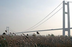
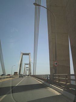
Vasco da Gama Bridge
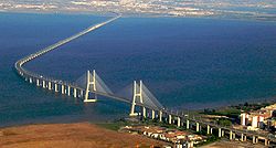
The Vasco da Gama Bridge (Portuguese: Ponte Vasco da Gama; pronounced [ˈpõt(ɨ) ˈvaʃku dɐ ˈɡɐmɐ]) is a cable-stayed bridge flanked by viaducts and roads that spans the Tagus River near Lisbon, capital of Portugal. It is the longest bridge in Europe (including viaducts), and ninth longest in the world, with a total length of 17.2 km (10.7 mi), including 0.829 km (0.5 mi) for the main bridge, 11.5 km (7.1 mi) in viaducts, and 4.8 km (3.0 mi) in dedicated access roads. Its purpose is to alleviate the congestion on Lisbon's other bridge (25 de Abril Bridge), and to join previously unconnected motorways radiating from Lisbon.
Penang Bridge
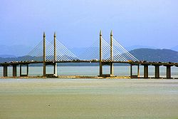
he Penang Bridge (Jambatan Pulau Pinang in Malay) is a dual-carriageway toll bridge that connects Gelugor on the island of Penang and Seberang Prai on the mainland of Malaysia on the Malay Peninsula. The bridge is also linked to the North-South Expressway in Prai and Jelutong Expressway in Penang. It was officially opened to traffic on September 14, 1985. The total length of the bridge is 13.5 km (8.4 miles), making it among the longest bridges in the world, the longest bridge in the country as well as a national landmark. Penang Bridge Sdn Bhd (PBSB) is the concession holder which manages it. The bridge was designed by a local Penang resident, Tan Sri Datuk Professor Ir. Chin Fung Kee, a well known authority in geotechnical engineering and former acting Vice Chancellor of the University of Malaya.
Rio–Niterói bridge
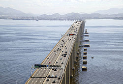
The Rio-Niterói Bridge is a Box girder bridge that connects the cities of Rio de Janeiro and Niterói in Brazil. It is currently the longest prestressed concrete bridge in the southern hemisphere, and the sixth longest in the world. From the year it was constructed until 1985 it was the world's second longest bridge, losing only to Lake Pontchartrain Causeway.
Confederation Bridge
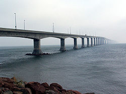
The Confederation Bridge (French: Pont de la Confédération) is a bridge spanning the Abegweit Passage of Northumberland Strait, linking Prince Edward Island with mainland New Brunswick, Canada. It was commonly referred to as the "Fixed Link" (cf. fixed link) by residents of Prince Edward Island prior to its official naming. Construction took place from the fall of 1993 to the spring of 1997, costing C$1.3 billion. The 12.9-kilometre (8 mi) long bridge opened on 31 May 1997[2].
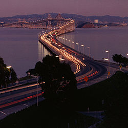
San Mateo – Hayward Bridge
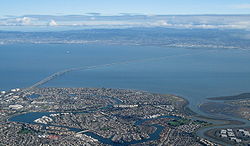
The San Mateo – Hayward Bridge (commonly called the San Mateo Bridge) is a bridge crossing California's San Francisco Bay in the United States, linking the San Francisco Peninsula with the East Bay. More specifically, the bridge's western end is in Foster City, the most recent urban addition to the eastern edge of San Mateo. The eastern end of the bridge is in Hayward. It is the longest bridge in the San Francisco Bay Area and the 25th longest in the world by length. The bridge is owned by the state of California, and is maintained by Caltrans, the state highway agency.
Sunshine Skyway Bridge
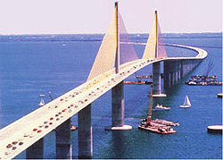
The Sunshine Skyway Bridge is a bridge spanning Tampa Bay, Florida, with a cable-stayed main span, and a length of 29,040 feet (exactly 5.5 miles or approximately 8.85 km).[4] It is part of I-275 (SR 93) and US 19 (SR 55), connecting St. Petersburg in Pinellas County and Terra Ceia in Manatee County, Florida, passing through Hillsborough County waters. Construction of the current bridge began in 1982, and the completed bridge was dedicated on February 7, 1987. The new bridge cost $244 million to build, and was opened to traffic on April 20, 1987. It replaced an older bridge constructed in 1954 and partly destroyed in a collision in 1980.
Third Mainland Bridge
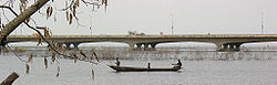
The Third Mainland Bridge is the longest of three bridges connecting Lagos Island, Lagos, Nigeria to the mainland, the other two being the Eko and Carter bridges. It is the longest bridge in Africa. The bridge starts from Oworonshoki which is linked to the Apapa-Oshodi express way and Lagos-Ibadan express way, and ends at the Adeniji Adele Interchange on Lagos Island. There is also a link midway through the bridge that leads to the Herbert Macaulay Way, Yaba. The Bridge was built by Julius Berger Nigeria PLC and opened by President Ibrahim Babangida in 1990: it measures about 11.8km in length.
Hosur Road Elevated Expressway
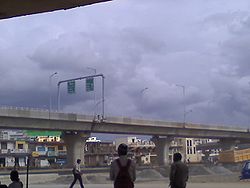
The Bangalore Elevated Tollway is a 9.985 kilometers (6 mi) long elevated, tolled, access controlled expressway in the city of Bengaluru, Karnataka, India. The project is a part of the BETL (Bangalore Elevated Tollways Ltd), project as part of the National Highways Development Project and the Elevated Highways Project. It was initiated in early 2006, and was inaugurated on 22nd January 2010.[1]
Expressway connecting Downtown Bangalore to Electronics City on Hosur Road
Expressway connecting Downtown Bangalore to Electronics City on Hosur Road
Richmond – San Rafael Bridge
The Richmond – San Rafael Bridge (officially, the John F. McCarthy Memorial Bridge) is the northernmost of the east–west crossings of the San Francisco Bay in California, USA, connecting Richmond on the east to San Rafael on the west end. It is commonly known as the Richmond Bridge, though in Richmond it is called the San Rafael Bridge. It opened in 1956 replacing ferry service by the Richmond – San Rafael Ferry Company.[1]
General Rafael Urdaneta Bridge
The General Rafael Urdaneta Bridge is located at the outlet of Lake Maracaibo, in western Venezuela. The bridge connects Maracaibo with much of the rest of the country. It is named after General Rafael Urdaneta, a Venezuelan hero in the War of Independence.
Yangpu Bridge
The Yangpu Bridge (simplified Chinese: 杨浦大桥; traditional Chinese: 楊浦大橋; pinyin: Yángpǔ Dàqiáo), in Shanghai, China, is among the world's longest bridges, with a total length of 8,354 meters. Its longest span of 602 m makes it the fourth largest cable-stayed bridge in the world. It carries the Inner Ring Road from the Yangpu District in Puxi to the Pudong New Area. It was completed in September 1993 and opened in October.
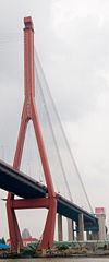
Sutong Bridge
The Sutong Bridge (simplified Chinese: 苏通大桥; Wu pronunciation: [sutʰoŋ dadʒɔ]) is a cable-stayed bridge that spans the Yangtze River in People's Republic of China between Nantong and Changshu, a satellite city of Suzhou, in Jiangsu province. With a span of 1,088 metres (3,570 ft), it is the cable-stayed bridge with the longest main span in the world as of 2009[update]. Its two side spans are 300 metres (980 ft) each, and there are also four small cable spans.[1]
Oresund Bridge
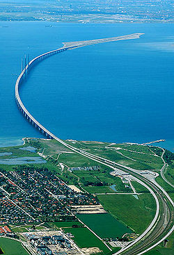
The Øresund or Öresund Bridge (Danish: Øresundsbroen, Swedish: Öresundsbron, joint hybrid name: Øresundsbron) is a combined two-track rail and four-lane road bridge-tunnel across the Öresund strait. It is the longest combined road and rail bridge in Europe and connects the two metropolitan areas of the Öresund Region: the Danish capital of Copenhagen and the Swedish city of Malmö. The international European route E20 runs across the bridge and through the tunnel via the two lane motorway, as does the Öresund Railway Line. The construction of the Great Belt Fixed Link and the Øresund have connected mainland Europe to Sweden and the rest of Scandinavia. The bridge was designed by the Danish architectural practice Dissing + Weitling.
James River Bridge
The James River Bridge is a four-lane divided highway lift bridge across the James River in the U.S. state of Virginia. Owned and operated by the Virginia Department of Transportation, it carries U.S. Route 17, U.S. Route 258, and State Route 32 across the river near its mouth at Hampton Roads. The bridge connects Newport News on the Virginia Peninsula with Isle of Wight County in the South Hampton Roads region, and is the easternmost such crossing without a tunnel component.
Huey P. Long Bridge (Jefferson Parish)
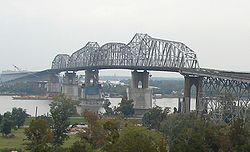
The Huey P. Long Bridge in Jefferson Parish, Louisiana, is a cantilevered steel through truss bridge that carries a two-track railroad line over the Mississippi River at mile 106.1 with two lanes of US 90 on each side of the central tracks.
Great Belt Fixed Link
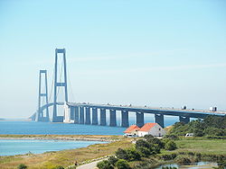
The Great Belt Fixed Link (Danish: Storebæltsforbindelsen) is the fixed link between the Danish islands of Zealand and Funen across the Great Belt. It consists of a road suspension bridge and railway tunnel between Zealand and the island Sprogø, as well as a box girder bridge between Sprogø and Funen. The "Great Belt Bridge" (Danish: Storebæltsbroen) commonly refers to the suspension bridge, although it may also be used to mean the beam bridge or the link in its entirety. The suspension bridge, known as the East Bridge, has the world's third longest main span (1.6 km). It is designed by the Danish architectural practice Dissing + Weitling.
Thanlwin Bridge (Mawlamyaing)
hanlwin Bridge (Mawlamyaing) is the longest bridge in Burma[1], and connects the city of Mawlamyaing with Mottama. Constructed at the confluence of the Thanlwin River, the Gyaing River and the Attayan River in Mon State, the bridge has a two-mile-long motor road and four-mile-long railroad as well as pedestrian lanes.[1]
Hernando de Soto Bridge
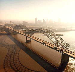
The Hernando de Soto Bridge is a through arch bridge carrying Interstate 40 across the Mississippi River between West Memphis, Arkansas and Memphis, Tennessee. It is often called the "M Bridge" as the arches resemble the letter M. Memphians also call the bridge the "New Bridge"[1], as it is newer than the Memphis & Arkansas Bridge (carrying Interstate 55) downstream.
